Catalogue de métadonnées
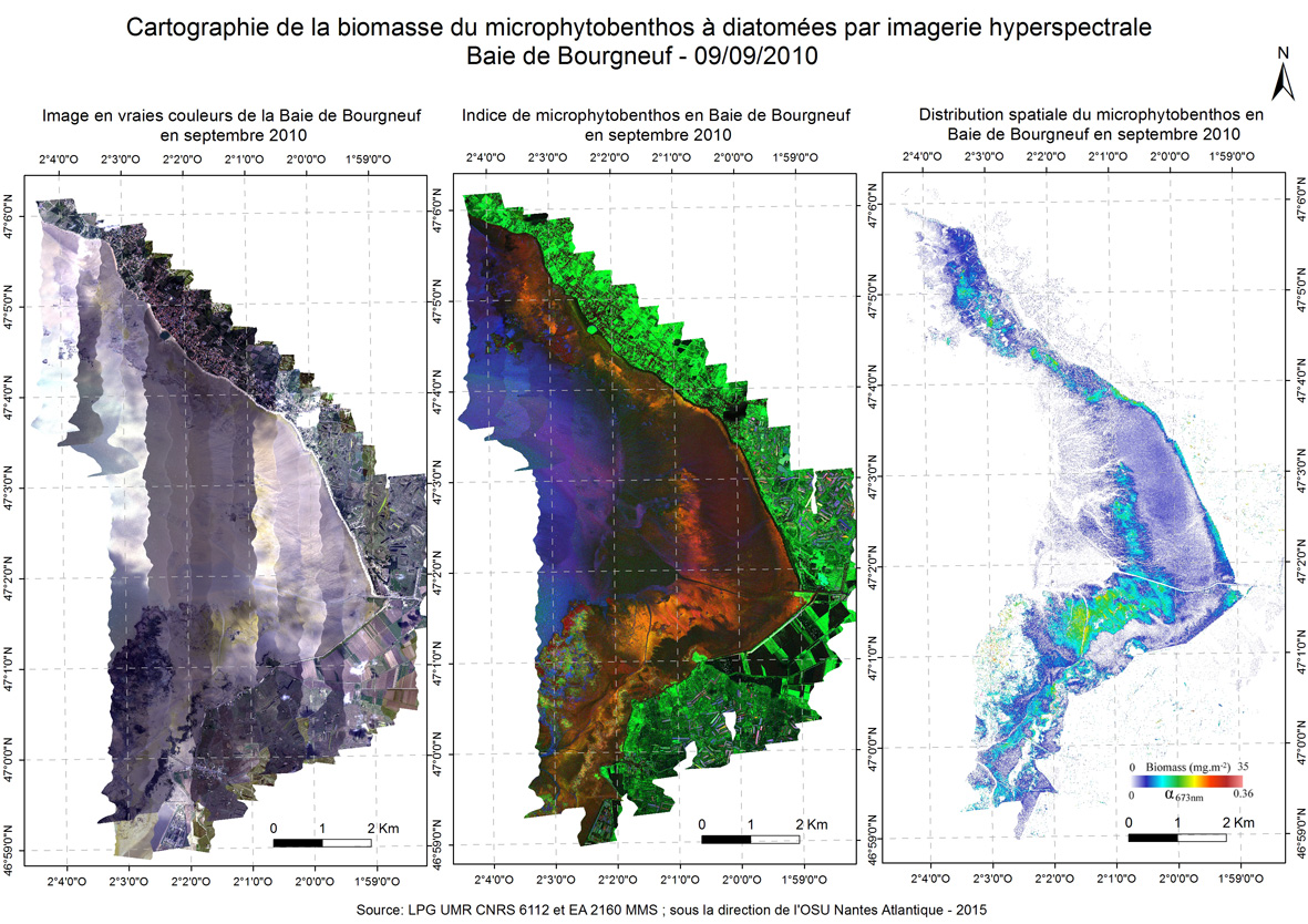
Cartographie de la biomasse du microphytobenthos à diatomées par imagerie hyperspectrale dans la Baie de Bourgneuf - septembre 2010
Biomass cartography of microphytobenthos at diatom with hyperscpectral images in Bay of Bourgneuf - september 2010
Une nouvelle approche de cartographie basée sur un modèle optique a été développée et utilisée à partir d'images aériennes hyperspectrales pour déterminer le biofilm du microphytobenthos et estimer leur biomasse dans des vasières difficilement accessibles ici en Baie de Bourgneuf sur des images de septembre 2010.
A new approach to mapping based on an optical model was developed and used from hyperspectral aerial images to determine the biofilm microphytobenthos and estimate their biomass in confined mudflats here in the Bay of Bourgneuf in 2010 september.
Simple
-
Date (Creation)Date (Création)
- 2010-09-09
-
Citation identifierIdentificateur
- https://ids.osuna.univ-nantes.fr/geonetwork/srv/resources0923f7a2-0e56-49d3-97a7-2e840e546184
-
StatusEtat
-
CompletedFinalisé
-
Region
-
-
France
France
-
-
ThemeThème
-
-
imagerie hyperspectrale
hyperspectral image
-
01 - Régional (Pays de la Loire)
Pays de la Loire
-
OSUNA
OSUNA
-
chlorophylle
chlorophyll
-
biomasse
biomass
-
-
PlaceLocalisation
-
-
Baie de Bourgneuf
Bay of Bourgneuf
-
-
GEMET - INSPIRE themes, version 1.0
-
-
Répartition des espèces
Species distribution
-
-
Limitation d'utilisationUse limitation
-
Le partenaire fournisseur n'est pas en mesure de garantir l’exactitude,la mise à jour,l’intégrité,l’exhaustivité des données et en particulier le fait qu'elles sont exemptes d'erreurs ou d'imprécisions,notamment de localisation,d’identification ou de qualification. Aucune garantie quant à l'aptitude des données à un usage particulier n'est apportée par le partenaire fournisseur. Les utilisateur·rices utilisent les données sous leur responsabilité pleine et entière,sans recours possible contre le partenaire fournisseur dont la responsabilité ne saurait être engagée du fait d’un dommage résultant directement ou indirectement de l’utilisation de ces données. En particulier,il appartient aux utilisateur·rices d’apprécier,sous leur seule responsabilité :l'opportunité d'utiliser les données; la compatibilité des fichiers avec leurs systèmes informatiques; l’adéquation des données à leurs besoins; qu’il·elles disposent de la compétence suffisante pour utiliser les données. Le fournisseur partenaire n’est en aucune façon responsable des éléments extérieurs aux données et notamment des outils d’analyse,matériels,logiciels,réseaux...,utilisés pour consulter et/ou traiter les données. L’utilisateur·rice veille à vérifier que l’actualité des informations mises à disposition est compatible avec l’usage qu’il·elle en fait.
Usage libre sous réserve des mentions obligatoires sur tout document de diffusion : "Source: sous la direction de l'OSU Nantes Atlantique"
Les données sont fournies sous la Licence Ouverte 2.0 ( https://www.etalab.gouv.fr/wp-content/uploads/2018/11/open-licence.pdf).
The supply partner is not in a position to guarantee the accuracy, up-to-dateness, integrity, completeness of the data and in particular that it is free from errors or inaccuracies, in particular with regard to location, identification or qualification. No guarantee is given by the supplying partner as to the suitability of the data for a particular purpose. Users use the data under their own responsibility, without any recourse against the partner supplier, who cannot be held liable for any damage resulting directly or indirectly from the use of these data. In particular, it is up to the users to assess, under their sole responsibility: the appropriateness of using the data; the compatibility of the files with their computer systems; the adequacy of the data to their needs; that they have sufficient competence to use the data. The partner supplier is not responsible for any elements outside the data, in particular the analysis tools, hardware, software, networks, etc., used to consult and/or process the data. The user shall ensure that the information made available is up to date and compatible with the use he/she makes of it.
Free use subject to the obligatory mentions on all distribution documents: "Source: under the direction of the OSU Nantes Atlantique".
The data is provided under the Open License 2.0 ( https://www.etalab.gouv.fr/wp-content/uploads/2018/11/open-licence.pdf).
-
Access constraintsContraintes d'accès
-
Other restrictionsAutres restrictions
-
Use constraintsContraintes d'utilisation
-
LicenseLicence
-
Spatial representation typeType de représentation spatiale
-
GridRaster
-
DistanceDistance de résolution
- 1 m
- Language
-
fre
-
Topic categoryCatégorie ISO
-
-
EnvironmentEnvironnement
-
-
DescriptionDescription
-
Baie de Bourgneuf en Région Pays-de-la-Loire
Pays de la Loire
))
-
Reference system identifierNom du système de référence
- EPSG / RGF93 / Lambert-93 (EPSG:2154) / 7.9
-
Distribution formatFormat (encodage)
-
-
GeoTIFFGeoTIFF
(
1.0
)
-
GeoTIFFGeoTIFF
(
1.0
)
-
OnLine resourceRessource en ligne
-
chloa_bourgneuf_20100909
(
OGC:WMS-1.3.0-http-get-map
)
Distribution spatiale du microphytobenthos en baie de Bourgneuf - 09-09-2010
-
OnLine resourceRessource en ligne
-
rgba_bourgneuf_20100909
(
OGC:WMS-1.3.0-http-get-map
)
Image en vraies couleurs de la baie de Bourgneuf - 09-09-2010
-
OnLine resourceRessource en ligne
-
indmpb_bourgneuf_20100909
(
OGC:WMS-1.3.0-http-get-map
)
Indice de microphytobenthos en baie de Bourgneuf - 09-09-2010
-
OnLine resourceRessource en ligne
- Digital Object Identifier (DOI) ( DOI )
-
OnLine resourceRessource en ligne
-
SOHLA:chloa_bourgneuf_20100909
(
OGC:WCS-1.1.0-http-get-capabilities
)
Distribution spatiale du microphytobenthos en baie de Bourgneuf - 09-09-2010
-
OnLine resourceRessource en ligne
-
SOHLA:rgba_bourgneuf_20100909
(
OGC:WCS-1.1.0-http-get-capabilities
)
Image en vraies couleurs de la baie de Bourgneuf - 09-09-2010
-
OnLine resourceRessource en ligne
-
SOHLA:indmpb_bourgneuf_20100909
(
OGC:WCS-1.1.0-http-get-capabilities
)
Indice de microphytobenthos en baie de Bourgneuf - 09-09-2010
-
Hierarchy levelNiveau
-
DatasetJeu de données
Conformance result
Résultat de conformité
-
Date (Publication)Date (Publication)
- 2010-05-31
-
Explication
-
L'article 7, paragraphe 1, de la directive 2007/2/CE correspond aux modalités techniques de l'interopérabilité : il s'agit du règlement relatif à l'interopérabilité : règlement n°1253/2013 du 21 octobre 2013 modifiant et complétant le règlement n°1089/2010 du 23 novembre 2010
-
PassDegré de conformité
- No
Conformance result
Résultat de conformité
-
Date (Publication)Date (Publication)
- 2010-05-31
-
Explication
-
-- information sur le test --
-
PassDegré de conformité
- No
-
Généralités sur la provenanceStatement
-
Le microphytobenthos est largement dominé par les diatomées, qui forment un biofilm à la surface des sédiments vaseux pendant la période diurne des basses eaux. Le microphytobenthos est constitué d’importants producteurs primaires et est la principale source de nourriture des invertébrés benthiques, comme les huîtres cultivées. L’estimation de la biomasse du microphytobenthos est donc un paramètre clé pour étudier le fonctionnement des écosystèmes de vasières. Ici a été choisi la chlorophylle A comme estimation de la biomasse, car la productivité du microphytobenthos est essentiellement basée sur ce pigment photosynthétique.
Le travail a été réalisé à partir d'images hyperspectrales prises à l'aide d’une caméra VNIR dont les caractéristiques dépendent du capteur utilisé. Les images ont été prises entre mai et septembre, en milieu de journée et à marée basse, c'est-à-dire au moment où le biofilm du microphytobenthos se développe. Le plan de vol a été programmé pour avoir suffisamment de temps pour couvrir l’ensemble de la zone intertidale à marée basse.
Les images ont été calées géographiquement à partir d'une zone bien visible proche d'une plage et située vers le 2 rue du Sauvetage - 44580 Les Moutiers en Retz (coordonnées GPS : 47.063153, -2.007174; 47.063311, -2.006709; 47.063209, -2.006576; 47.063028, -2.007047).
Avant toute analyse les images ont subi une correction atmosphérique avec l’algorithme FLAASH (Fast Line-of-sight Atmospheric Analysis of Spectral Hypercubes) qui inclue les codes de transferts radiatif MODTRAN4 (voir Matthew et al, 2000. Status of atmospheric correction using a MODTRAN4 based algorithm. SPIE Proceedings, Algorithms for Multispectral, Hyperspectral, and Ultraspectral Imagery VI. Vol. 4049, pp. 199-207) pour convertir les images de radiance en images de réflectance libres de caractéristiques atmosphériques. Des mesures ont été effectuées auparavant en laboratoire, celles-ci représentants une petite fraction de la zone intertidale (car il est difficile d’accéder à la vasière), et ont été extrapolées à une échelle plus grande, avec précaution, avec l’utilisation des images hyperspectrales.
La première étape d’analyse des images hyperspectrales a consisté à différencier le biofilm des diatomées du microphytobenthos, et ainsi masquer les pixels contenant d’autres organismes photosynthétiques. Seules les diatomées sont prises en compte ici, car le modèle physique développé pour quantifier la biomasse ne tient compte que des caractéristiques de ce groupe de microalgues. Les Euglènes, qui sont un autre groupe important du microphytobenthos, sont donc également exclu du masque. Il a été montré en laboratoire que le biofilm du microphytobenthos n’absorbe pas ni ne réfléchit la lumière dans des gammes de longueurs d’onde du proche infrarouge, contrairement aux macroalgues. Les microalgues contiennent beaucoup moins de pigments que les macroalgues, et présentent des caractéristiques d’absorption faible et étroite qui donnent un pic de réflectance caractéristique à environ 580 nm dû aux bandes d’absorption de la chlorophylle et de la caroténoïde. Ceci a permis de définir un indice du microphytobenthos : MPBI, afin de restreindre la zone d’intérêt. En laboratoire, Les Euglènes et les diatomées, qui sont les 2 groupes les plus représentés dans le microphytobenthos de la Région Pays de la Loire, présentent tous les 2 une forte concentration de chlorophylle A, et présentent pour ce pigment le même spectre de réflectance pour la bande d’absorption de 673 nm. Par contre, ils présentent des différences de réflectance de par leur assemblage propre en pigments :
-les Euglènes contiennent de la chlorophylle B, qui élargit la fonction d’absorption jusqu’à 673 nm,
-les diatomées contiennent de la chlorophylle c et surtout de la fucoxanthine, cette dernière présentant un fort pic d’absorption entre 540 et 550 nm. Ces propriétés ont permis de sélectionner les pixels les plus représentatifs des diatomées sur les images, en travaillant sur la présence/absence de fucoxanthine. Ainsi le pic du spectre d’absorption a été défini à 553 nm pour les euglènes et à 600 nm pour les diatomées, pour définir un indice de diatomées : IDiatomée et un indice d’euglènes : IEuglène.
Voici la démarche suivie pour déterminer les pixels à diatomées :
1)Un premier masque a été utilisé à partir de NDVI (Indice de végétation par Différence Normalisée) pour calculer un masque binaire de surface non végétalisé en utilisant une valeur minimale de NDVI de 0,1 (ici calculé à partir de la résolution du capteur HySpeX)
NDVI = (R800-R673)/(R800+R673) (R= réflectance)
2)Puis un deuxième masque a été appliqué, calculé à partir de l’indice du microphytobenthos
IMPB = (2R586/(R495+R673))-1 pour différencier le microphytobenthos du reste de la végétation
Si IMPB est supérieur à NDVI, le pixel est gardé car il correspond plus à du microphytobenthos, sinon il est masqué. Il a également été défini que si IMPB est inférieur à 0,25 il correspond à du sédiment nu et est donc également masqué.
3)Enfin un dernier masque a été appliqué, pour différencier les diatomées des euglènes, calculés à partir de l’indice des Euglènes et de l’indice des diatomées :
IEuglène = (2R553/(R600+R495))-1
IDiatomée = (2R600/(R459+R673))-1
Seul sont alors gardés les pixels présentant un IDiatomée supérieur à IEuglène
La deuxième étape a consisté à déterminer la biomasse du microphytobenthos à partir des images obtenues suite à la sélection des pixels, exprimée en mg de chlorophylle A par m². Un modèle de transfert radiatif du biofilm microphytobenthique (MPBOM) développé au préalable (voir la thèse de Farzaneh Kazemipour, 2011) a été utilisé pour déterminer la quantité de biomasse de diatomées. Le MPBOM a consisté à calculer le spectre du coefficient d’absorption du spectre de réflectance mesuré. En laboratoire il a été possible de déterminer la régression linéaire entre les coefficients d’absorption de la chlorophylle A à 673 nm et les valeurs de biomasse pour ensuite déterminer in situ à partir des images la quantité de biomasse à partir du coefficient d’absorption obtenu avec MPBOM.
La biomasse du microphytobenthos a été déterminée par cette formule :
biomasse = 96.9 x coefficient d'absorption de la chlorophylle A à 673 nm (R2=96%).
Pour calculer le MPBOM, ont été pris en compte ici le spectre de réflectance du substrat, ainsi que les paramètres environnementaux. Ceci a permis de réaliser la cartographie de la biomasse du microphytobenthos.
le travail d'acquisition des images a été financé par les programmes GEOPAL(Etat - Région des Pays de la Loire - FEDER)et OSUNA, et réalisé par la société ACTIMAR. Le capteur a été financé par un Contrat de Plan Etat-Région, le département Loire Atlantique, le FNADT et le FEDER. Le travail a été réalisé à partir d'images hyperspectrales prises à l'aide d’une caméra VNIR HySpex avec une résolution spectrale de 4,5 nm dans 160 canaux entre 400 et 1000 nm de gamme spectrale. La caméra a été utilisée à partir d'un avion, à 2500 m d'altitude, pour un angle d'ouverture de 17°. Les images ont été prises entre mai et septembre, en milieu de journée et à marée basse, c'est-à-dire au moment où le biofilm du microphytobenthos se développe. Le plan de vol a présenté 10 passages avec un décalage de temps consécutif d'environ 8 minutes.
Les travaux d’analyses ont été réalisés par le Laboratoire de Planétologie et Géodynamique de Nantes, UMR CNRS 6112, et le Laboratoire Mer Molécules Santé, EA 2160, Université de Nantes.
Kazemipour F., V. Méléder, P. Launeau (2011) “Optical properties of microphytobenthic biofilms (MPBOM): Biomass retrieval implication”. Journal of Quantitative Spectroscopy and Radiative Transfer, Volume 112, Issue 1, January 2011, Pages 131-142
Kazemipour, F., (2011) Caractérisation hyperspectrale des biofilms microphytobenthiques : Cartographie de la biomasse de la micro à la macro échelle. Thèse de Doctorat de l’Université de Nantes. 198 p.
Kazemipour, F., P. Launeau, V. Méléder (2012) “Microphytobenthos biomass mapping using the optical model of diatom biofilms: Application to hyperspectral images of Bourgneuf Bay”. Remote Sensing of Environment 127, 1–13
Benyoucef I., 2014. Télédétection visible proche-infrarouge de la distribution du microphytobenthos estuarien. Thèse de Doctorat de l’Université de Nantes. 225 p.
The microphytobenthos is largely dominated by diatoms , which form a biofilm on the surface of muddy sediments during the diurnal period of low water. The microphytobenthos consists of important primary producers and is the main food source for benthic invertebrates such as oysters cultivated . The estimate of biomass microphytobenthos therefore a key parameter for studying the functioning of mudflat ecosystems. Here has been chosen as the chlorophyll a biomass estimate because microphytobenthos productivity is essentially based on the photosynthetic pigment.
The work was made from hyperspectral images taken using a VNIR camera whose characteristics depend on the sensor used. The images were taken between May and September , at midday and at low tide, that is to say when the microphytobenthos biofilm develops. The flight plan was scheduled to have enough time to cover all of the intertidal zone at low tide.
Before analyzing the images underwent atmospheric correction with flaash algorithm ( Fast Line -of-sight Atmospheric Analysis of Spectral Hypercubes ) that includes the codes of radiative transfer MODTRAN4 (see Matthew et al , 2000. Status of atmospheric corrected using a MODTRAN4 based algorithm . SPIE Proceedings , Algorithms for Multispectral , Hyperspectral , and ultraspectral imagery VI . Vol. 4049 , pp . 199-207 ) to convert images of radiance images free of airborne reflectance characteristics . Measurements were carried out previously in the laboratory , these representatives a small fraction of the intertidal zone ( as it is difficult to access the mudflat ) and were extrapolated to a larger scale, with care , with the use hyperspectral images.
The setting point has coordinates used : -2.171169543 ; 47.29112657 , located in the municipality of MONTOIR-DE-BRETAGNE.
The first step of analyzing hyperspectral images has been to differentiate the biofilm microphytobenthos diatoms, and thus mask pixels containing other photosynthetic organisms. Only diatoms are taken into account here because the physical model developed to quantify biomass takes into account only the characteristics of this group of microalgae. The euglena, which are another important group microphytobenthos, are therefore also excluded from the mask. It has been shown in the laboratory that the biofilm microphytobenthos not absorb or reflect light in wavelength ranges of near infrared, in contrast to macroalgae. Microalgae contain less pigment than macroalgae, and have low and narrow absorption characteristics that give a characteristic peak at about 580 nm reflectance due to absorption bands of chlorophyll and carotenoid. This helped to define an index microphytobenthos: MPBI to restrict the area of interest. In the laboratory, the euglena and diatoms, which are the two most represented groups in the microphytobenthos the Region Pays de la Loire, exhibit every 2 a high concentration of chlorophyll A, and have for this pigment the same reflectance spectrum the absorption band of 673 nm. By cons, there are differences in reflectance by their own assembly pigments:
-the euglena contain chlorophyll B, which broadens the absorption function to 673 nm,
-the diatoms contain chlorophyll c and fucoxanthin especially, the latter having a strong absorption peak between 540 and 550 nm. These properties were used to select the most representative pixels of diatoms on images, working on the presence / absence of fucoxanthin. Thus the peak of the absorption spectrum was set to 553 nm for euglena and 600 nm for diatoms, to define an index of diatoms IDiatomée and an index of euglena: IEuglène.
Here is the process used to determine the diatomaceous pixels:
1) A first mask was used from NDVI (Vegetation Index Normalized Difference) to calculate a binary mask non vegetated surface using a minimum NDVI value of 0.1 (here calculated from the sensor resolution HySpeX)
NDVI = (R800-R673) / (R800 + R673) (R = reflectance)
2) Then a second mask has been applied, calculated from the index microphytobenthos
IMPB = (2R586 / (R495 + R673)) - 1 to differentiate microphytobenthos the remainder of the growing
If IMPB exceeds NDVI, the pixel is kept as it corresponds more to microphytobenthos, otherwise hide it. It was also defined that if IMPB is less than 0.25 it corresponds to the naked sediment and is also masked.
3) A final mask was applied to differentiate diatoms euglena, calculated from the index and the index euglena diatoms:
IEuglène = (2R553 / (R600 + R495)) - 1
IDiatomée = (2R600 / (R459 + R673)) - 1
Only then are kept the pixels having a higher IEuglène than IDiatomée.
The second step was to determine the biomass microphytobenthos from images obtained following the selection of the pixels, expressed in mg of chlorophyll A per m². A radiative transfer model microphytobenthic biofilm (MPBOM) developed previously (see thesis Kazemipour Farzaneh, 2011) was used to determine the amount of diatom biomass. The MPBOM was to calculate the spectrum of the absorption coefficient of the measured reflectance spectrum. In the laboratory it was possible to determine the linear regression between the absorption coefficient of chlorophyll a to 673 nm and the biomass values then determine in situ from images, the amount of biomass from the obtained absorption coefficient with MPBOM.
Microphytobenthos biomass was determined by the formula:
biomass = 96.9 x coefficient of chlorophyll A absorption at 673 nm (R2 = 96%).
To calculate the MPBOM, were taken into account here the reflectance spectrum of the substrate and environmental parameters. This helped to achieve biomass mapping microphytobenthos.the image acquisition work was funded by GEOPAL programs ( State - Region of Pays de la Loire - ERDF) and OSUNA , and directed by the ITF CONSULTING society. The sensor was funded by a State-Region Contract Plan, the Loire Atlantic, FNADT and ERDF . The work was made from hyperspectral images taken using a VNIR HySpex camera with a spectral resolution of 4.5 nm to 160 channels of 400 to 1000 nm spectral range . The camera was used from a plane at 2,500 meters, to an opening angle of 17 °. The images were taken between May and September , at midday and at low tide, that is to say when the microphytobenthos biofilm develops.
The work analyzes were performed by the Laboratory of Planetology and Geodynamics of Nantes, CNRS UMR 6112 , Laboratoire Sea Molecules and Health , EA 2160 , Université de Nantes .
-
File identifierIdentifiant de la fiche
- 0923f7a2-0e56-49d3-97a7-2e840e546184 XML
- Metadata language
-
fre
-
Character setJeu de caractères
-
UTF8Utf8
- Parent identifier
-
Biomass cartography of microphytobenthos at diatom with hyperscpectral images
fbfede52-b320-4986-8afc-deef4dc722aa
-
Hierarchy levelType de ressource
-
DatasetJeu de données
-
Date stampDate des métadonnées
- 2023-04-17T15:54:01
- Metadata standard name
-
ISO 19115
- Metadata standard version
-
1.0
Overviews
Spatial extent
Provided by